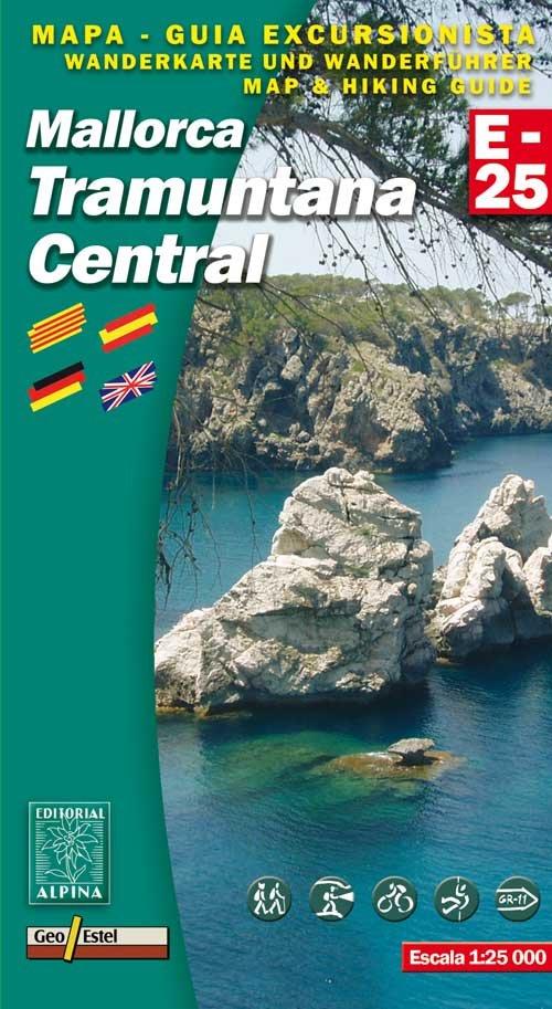
Mallorca Tramuntana Central Map
Editorial Alpina produce an extensive range of walking maps covering key hiking areas of Spain.
The maps are contoured at 10 and 20 m intervals and feature hill shading and summit heights. All maps also feature long distance footpaths and hiking trails, campsites and camping huts. Each title has a separate booklet with general information on the area, descriptions of selected hiking routes, a list of accommodation with addresses, etc. and is presented in a plastic wallet.
The maps are contoured at 10 and 20 m intervals and feature hill shading and summit heights. All maps also feature long distance footpaths and hiking trails, campsites and camping huts. Each title has a separate booklet with general information on the area, descriptions of selected hiking routes, a list of accommodation with addresses, etc. and is presented in a plastic wallet.
- Legend in English
- Scale 1/25,000
- Coverage: GR11; Fornalutx; Puig Major; Valldemossa; Puig d'Alaro' GR 221
- ISBN 9788480903585
- GPS compatible
- size: 155cm x 80cm
$12.50
Mallorca Tramuntana Central Map—
$12.50
Mallorca Tramuntana Central Map
Editorial Alpina produce an extensive range of walking maps covering key hiking areas of Spain.
The maps are contoured at 10 and 20 m intervals and feature hill shading and summit heights. All maps also feature long distance footpaths and hiking trails, campsites and camping huts. Each title has a separate booklet with general information on the area, descriptions of selected hiking routes, a list of accommodation with addresses, etc. and is presented in a plastic wallet.
The maps are contoured at 10 and 20 m intervals and feature hill shading and summit heights. All maps also feature long distance footpaths and hiking trails, campsites and camping huts. Each title has a separate booklet with general information on the area, descriptions of selected hiking routes, a list of accommodation with addresses, etc. and is presented in a plastic wallet.
- Legend in English
- Scale 1/25,000
- Coverage: GR11; Fornalutx; Puig Major; Valldemossa; Puig d'Alaro' GR 221
- ISBN 9788480903585
- GPS compatible
- size: 155cm x 80cm
Product Information
Product Information
Shipping & Returns
Shipping & Returns
Description
Editorial Alpina produce an extensive range of walking maps covering key hiking areas of Spain.
The maps are contoured at 10 and 20 m intervals and feature hill shading and summit heights. All maps also feature long distance footpaths and hiking trails, campsites and camping huts. Each title has a separate booklet with general information on the area, descriptions of selected hiking routes, a list of accommodation with addresses, etc. and is presented in a plastic wallet.
The maps are contoured at 10 and 20 m intervals and feature hill shading and summit heights. All maps also feature long distance footpaths and hiking trails, campsites and camping huts. Each title has a separate booklet with general information on the area, descriptions of selected hiking routes, a list of accommodation with addresses, etc. and is presented in a plastic wallet.
- Legend in English
- Scale 1/25,000
- Coverage: GR11; Fornalutx; Puig Major; Valldemossa; Puig d'Alaro' GR 221
- ISBN 9788480903585
- GPS compatible
- size: 155cm x 80cm